Tuesday, December 22, 2009

Two Days to GO


Just two more days and I will be looking out at this view again and trying to figure out a plan. The plan will be to sell-off what real estate we have in North Alabama and finding someone with a great bluewater sailboat, motorsailor, or catamaran in the Baja Area that wants to trade for a Grand Banks Trawler located on the Tennessee River and conveniently placed to cruise the Eastern third of the U.S. in what is called The Great Loop. Now that second part of finding someone who wants to trade boats, may not be as difficult as it sounds. For me it will seem more challenging to sell a house in the Historic Albany District, a commercial complex in Old Decatur and a riverside townhome. But, as is likely to be the case with all of these obstacles, it can be as easy as simply putting the sign up "For Sale" and then setting the price so fair and attractive that they sell almost immediately.
For example, the house four doors down to the East of us was listed with a realtor and sold for full price within one week. And then there is the case of the house three doors to the West that was placed "For Sale by Owner" and sold within 24 hrs. Both of these actually happened within the last month or two. I guess it will be up to me to set a good price and be ready for a quick sale. That is hard when you have spent nearly two decades in one location.......

Safety in Mexico


Whenever I talk to folks seriously about our "Plans to Retire in Mexico", the first question is always regarding safety. Not only do I feel that we are indeed safer in Mexico than in the United States, we are focusing our efforts on the single safest state (out of 32) in all of Mexico. The Baja Sur reported only one homocide in all of 2008, which is 100 times safer than the same population area of North, Alabama (including Birmingham). In fact our little city of Decatur reported one homicide for 2008, Huntsville, 28 and Birmingham much more than that. Not only is the area of focus, San Jose del Cabo nearly a thousand miles south of the drug cartel related violence at the border, it is the most sparcely populated state in all of Mexico. Here are some well made points and statistics from Arthur Frommer-

Arthur Frommer, publisher of the famed travel guides, recently traveled to Mexico and stated, “In actual fact, the resort areas of Mexico . . . have experienced no violence directed against tourists and are, in fact, almost totally serene, as I myself witnessed on a recent stay. It is as safe to vacation in the tourist part of Mexico today as to go to any city of the U.S. or Canada.”

Arthur Frommer makes a good point. Looking at crime statistics, it would appear that Americans are safer in Mexico than they are in many parts of the United States. The United States is the most crime-ridden country in the world. Mexico is not even in the top five. The top five are (based on total crimes per country):

1. United States – 11,877,218
2. United Kingdom – 6,523,706
3. Germany - 6,507,394
4. France - 3,771,850
5. Russia – 2,952,370

On a per capita basis, the United States ranks 8th, while Mexico is 39th. Reporting that all of Mexico is not safe based on violence in three or four cities is like saying that the United States is dangerous based on the crime statistics for New Orleans (209 murders in 2008), Detroit and East Los Angeles. In 2008, more Americans died in New Orleans (one city) than in all of Mexico.


With all of that, and 360 days a year of sunshine, wouldn't you feel safer there?

A Little History of San Jose del Cabo


Spanish galleons first visited Estero San Jose at the mouth of the Rio San Jose to obtain fresh water near the end of their lengthy voyages from the Philippines to Acapulco in the late 17th and early 18th centuries. As pirate raids along the coast between Cabo San Lucas and La Paz became a problem, the need for a permanent Spanish settlement at the tip of the cape became increasingly urgent. The growing unrest among the Guaycura and Pericu Indians south of Loreto also threatened to engulf mission communities to the north. As a result, the Spanish were forced to send armed troops to the Cape region to quell the Indian uprisings in 1723, 1725 and 1729.

In 1730, Jesuit Padre Nicholas Tamaral traveled south from Mission La Purisima and founded Mission San Jose del Cabo on a mesa overlooking the Rio San Jose some 5 km. north of the current town site. Due to the overwhelming presence of mosquitoes at this site, Tamaral soon moved the mission to the mouth of the estuary on a rise flanked by Cerro del Vigia and Cerro de la Cruz.Tamaral and the Pericus got along fine until he pronounced an injunction against Polygamy, a long tradition in Pericu society. After Tamaral punished a Pericu Shaman for violating the anti-polygamy decree, the Indians rebelled and burned both the San Jose and Santiago missions in October of 1734. Tamaral was killed in the attack. Shortly thereafter the Spanish established a presidio, which served the dual purpose of protecting the community from insurgent Indians and the estuary from English pirates.

By 1767, virtually all the Indians in the area had died either of European diseases or in skirmishes with the Spanish. Surviving mission Indians were moved to missions farther north, but San Jose del Cabo remained an important Spanish military outpost until the mid-19th century when the presidio was turned over to Mexican nationals.

During the Mexican American War (1846-48), marines from the U.S. frigate Portsmouth briefly occupied the city. A bloody siege ensued and the Mexicans prevailed under the leadership of Mexican Naval officer Jose Antonio Mijares. Plaza Mijares, San Jose's town Plaza is named to commemorate his victory. As mining in the Cape Region gave out during the late 19th and early 20th centuries, San Jose del Cabo lost population along with the rest of the region. A few farmers and began trickling into the San Jose area in the 30s and in 1940 the church was rebuilt.

San Jose del Cabo remained largely a backwater until the Cape began attracting sportfishers and later the sun-and-sand-set in the '60s and '70s. Since the late 1970s, FONATUR (Foundation Nacional de Fomento del Turismo or National Foundation for Tourism Development) has sponsored several tourist development projects along San Jose's shoreline. Fortunately, the developments have done little to change San Jose's Spanish colonial character. Local residents take pride in restoring the towns 18th century architecture and preserving its quiet, laid back ambiance.

In November of 1993, a severe storm wreaked havoc on beachside condos near San Jose del Cabo but the town itself suffered little damage. Today, San Jose del Cabo provides a welcome respite from the busy, fiesta atmosphere found twenty miles south in Cabo San Lucas.


A Handy Mileage Chart for Highway 1

Highway 1 / Distance Table

Tijuana


68 109km Ensenada


187 301km 119 191km San Quintin


223 359km 155 249km 36 58km El Rosario


444 714km 376 605km 257 414km 221 356km Guerro Negro


532 856km 464 747km 345 555km 309 497km 88 142km San Ignacio


557 928km 509 819km 390 628km 354 570km 133 215km 45 73km Santa Rosalia


615 990km 547 880km 428 689km 392 631km 171 276km 83 134km 38 61km Mulegé


669 1125km 631 1015km 512 824km 476 766km 255 412 167 270km 122 197km 84 136km Loreto


788 1268km 720 1158km 601 667km 565 909km 344 555km 256 413km 211 340km 173 279km 89 143km Ciudad Constitución

922 1483km 854 1374km 735 1183km 699 1125km 478 771km 390 629km 345 556km 307 495km 223 359km 134 216km La Paz
1059 1704km 991 1594km 872 1403km 836 1345km 615 992km 527 850km 482 777km 444 716km 360 580km 271 437km 137 221km Cabo San Lucas

Sunday, December 20, 2009

The 6,000 Mile Journey of the Gray Whales


Whales

The migration of the California Gray Whale is one of the most amazing animal behaviors on record. Every winter, beginning in mid-October, Gray whales (Eschrichtius robustus) migrate south from the Bering Sea to the warm lagoons of Baja California (6,000 miles). Breeding along the way, they arrive at the lagoons in December and January and it is here that they give birth to their young. When the calves have grown big enough for the trip home the whales start heading north again from February to May.

There are three major breeding grounds in Baja: Laguna Ojo de Liebre (once known as Scammon’s Lagoon, see below), Laguna de San Ignacio and Bahia Magdalena. Laguna Ojo de Liebre is also the home to the Parque Natural de la Ballena Gris, a national park.

Gray whales are baleen whales. This term refers to the bristled plates that hang downward on either side of their upper jaws. These bristles act as a sieve to filter food out of the water. Their upper jaws can expand when taking in large amounts of water and when the water is forced through the bristles, small invertebrates are left behind and eaten. An adult gray whale can eat approximately 2,600 lbs (1,200kg) of these small crustaceans. When migrating and calving however, the grays eat very little.

Gray whales are mottled gray in color. They are covered in barnacles and usually have scrapes and scars from feeding along the bottom and from encounters with their only water-borne enemy, the Killer Whale. Gray whales have no dorsal fin but have a low hump followed by 9-12 knobs. The flippers are large and paddle-shaped and the tail very broad, its width equaling almost 25% of the body length.

Gray whales are slow swimmers, averaging 3-5 mph (5-8 kph). When traveling, the make shallow dives of 4-5 minutes and then surface to blow 3 or 4 times. Grays also like to breach (leaping out of the water) and spyhop (raising their heads out of the water). These behaviors are not understood but may have to do with breeding or navigation.

In 1857, an American Whaling captain named Charles Melville Scammon heard about the whales’ migration to Baja. Following a pod of whales into a small lagoon, he determined that the traditional harpooning wouldn’t work to kill them. He devised a new method and in the small confines of the lagoons, was able to slaughter hundreds of whales a year, selling their oil and blubber for great profit.

By the 1930’s, nearly all the gray whales had been eliminated. It wasn’t until 1972 when the U.S. government passed the Marine Mammal Protection Act that the gray whale began a comeback. Now, thirty years later, the comeback of the gray whale is considered one of the greatest successes of the environmental movement.

Be sure to check the Gray Whale Fact Sheet and these great Gray Whale Photos.

Baja Information

Geography and Climate

Mexico is a very large country spreading southeast from its northern border with the United States to the Caribbean Sea and from the Pacific Ocean on the west and south to the Gulf of Mexico on the east. Mexico covers almost 2 million square kilometers (460,000 sq. mi.) and also shares borders with Guatemala and Belize.

In the northwest portion of the country is the Baja Peninsula. At 800 miles long it is one of the longest peninsulas in the world. The peninsula is also very narrow averaging less than 70 miles in width with the narrowest part being 26 miles wide.

20 million years ago, there was no Baja Peninsula. The land was originally connected to the Mexican mainland with the tip of Baja located near Puerto Vallarta. Thanks to the San Andreas Fault and the movement of the earth’s plates Baja is now is nearly 300 miles away from its old neighbor.

Baja's mountains form a largely unbroken barrier running the entire length. The mountains are actually a series of ranges each with their own name. The mountains average between 2,000 and 3,000 feet. The tallest mountains on the peninsula are the twin peaks of Picacho del Diablo, or Devil's Peak, which rise to 10,154 feet.

There are four main desert areas on the peninsula. These are the San Felipe Desert, the Central Coast Desert, the Vizcaíno Desert and the Magdalena Plain Desert.

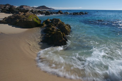
Being a peninsula, two of Baja three sides are water. The Pacific coast is characterized by ocean swells and the occasionally heavy surf. Due to upwelling of deep ocean water, the water temperature is cool though it warms as the water mover south.

The Sea of Cortez is over 600 miles long and in places, the depth reaches more than 14,000 feet. With its location along the San Andreas Fault, the Cortez is very seismically active. Earthquakes in the 1800's destroyed the towns of San Ignacio and Loreto.

Due to its long narrow shape, the Cortez produces one of the largest tidal ranges in the world. Near the Colorado River Delta the tides can fluctuate up to 31 feet between high and low tides. Water temperature can also vary by large extremes. Depending on the season and the location, the temperature can vary from a high of 91°F to a low of 47°F.

Climate

Much of northern Baja California has a climate similar to Southern California. Along the Pacific coast the summers are warm with cool night, while the winter is cool with chilly nights. The Sea of Cortez has hot summers days and humid nights, while the winter is cooler with strong cold winds. Most of the rain falls along the Pacific coast in the winter, with an average of 10 inches of rainfall a year.

The southern half of Baja is more sub-tropical. Summers are hot and humid, while winter evenings can be cool. Rain is rare and mostly in the summer in the form of violent storms.

What is the weather like in Baja California today? Follow these links to The Weather Underground for La Paz, Loreto, Cabo San Lucas or Tijuana. Or check out this satellite map from Weather.com or from Earthwatch.com.

Try converting the temperature in your town from Fahrenheit to Celsius.

Temp. converter: Enter a number and click outside the box
F: C:

What time is it in Baja California as compared to the time in your home town? Check this!

A Great Introduction to San Jose del Cabo-"The Real Cabo"


San Jose del Cabo The ‘Real Cabo’...

If you are unfamiliar with what constitutes ‘Los Cabos’ it goes like this: located on the most southern extremity of Baja California Sur, the rowdy raucous resort community of Cabo San Lucas is on the west end of the peninsula tip and approximately eighteen miles to the east, you will find the more laidback, peaceful, colonial town of San Jose del Cabo. Los Cabos (The Capes) includes both communities connected by a eighteen-mile stretch of waterfront hotels, celebrity designed golf courses and luxury home developments.

Cabo San Lucas is the generally agreed upon dividing line between the oceans of the Sea of Cortez and the Pacific. In fact, at the bay entrance where the famous ‘Land’s End’ arch rock formations are to be found – on one side of the arch are the relatively cooler waters of the Pacific and on the other, the always-warmer Sea of Cortez.


Cabo San Lucas was designed literally from ground-up by the Mexican government to be a tourist destination resort a couple of decades ago. Its sole purpose is to generate tourism, jobs, and to send 90% of the tax revenues back to Mexico. And it’s been wildly successful. It’s flashy and new. It rocks. It’s fun to visit, but like the Vegas Strip, would you want to live there?

For many tourists, after visiting fast and frenetic Cabo San Lucas the first time, San Jose del Cabo ends up being their destination of choice for future visits. Indeed most folks come to Mexico to get away, take it slow and appreciate the ambience as found in San Jose del Cabo, what I call the ‘Real Cabo’.

San Jose del Cabo was for hundreds of years, the only community here at the tip fo the Baja California Peninsula. With its natural fresh water oasis flowing into palm-lined lagoons at the oceans edge, the area supported Indian communities and hundreds of species of wildlife for thousands of years before colonization by the Spanish. During the pre-colonial period it was a watering and provisioning stop for Spanish galleons. The heavy ships laden with treasure, silks and spices from the east were the ‘big game fish’ then for pirates like Sir Francis Drake who came looking for ‘donations’ to his favorite charity (himself) and his majesty the 'Virgin' Queen Elizabeth. San Jose del Cabo was finally settled in 1730 with a Jesuit mission and fort to help stabilize the region against these marauders.

As the years went by, explorers like Cabrillo and Vizcaino, cannoned warships, whaling ships, and clipper traders running the West Coast all stopped and often left, leaving crew behind. Some of the old families in Todos Santos, La Paz and San Jose del Cabo have English and French derived surnames from ancestors who were buccaneers before jumping ship and becoming ranchers and fishermen.

San Jose del Cabo for hundreds of years has been an outpost on the tip of the Baja California peninsula. Up until twenty years ago Cabo San Lucas was just a few farmhouses, some scrawny cattle roaming the dirt roads and a fish cannery. There was only a twenty-mile dirt road connecting it to the only town nearby, San Jose del Cabo.

The quaint town of San Jose del Cabo has an almost fantasy land quality about it. Imagine main street Disneyland without that big rat walking about shaking hands. In city center one will find a gorgeous Spanish colonial styled city hall with murals of old Baja inside its corridors. Within, there’s a two-story courtyard shaded by a huge Mexican Laurel.

Often one can enjoy an art exhibit or concert here in the evenings. Out front on Mijares (the main street) is a block long fountain dividing traffic on the street lined with plastered and columned old colonial buildings and almost secret paseos or inner courtyards full of shops graced with bougainvilleas, palms and laurels. Adjacent is a one acre tiled plaza shaded with gigantic palms and century old trees surrounding a Victorian bandstand and a newer outdoor stage for larger performances.

Often in the evenings on the plaza in front of the cathedral, one can enjoy traditional Mexican bands, Latin dance and rock and roll music. One can literally dance under the stars here, or in one of the nearby clubs as in the Tropicana Inn (located across the street from the municipal palace). The Tropicana Inn often features fine Cuban or Mexican bands as well as romantic covered outside dining along the boulevard.

San Jose del Cabo exhibits the best of traditional Mexico with its blocks of unhurried streets and graceful tree covered sidewalks, its scores of shops, galleries, fine restaurants, boutiques and total absence of popular franchises such as McDonalds, Pizza Hut, and Hard Rock Cafe. It’s a place to explore, unwind, take-in and treasure.

San Jose del Cabo hosts many excellent restaurants, which are typically uncrowded, low keyed and elegant compared to the more tourist oriented Cabo San Lucas establishments. Good picks are El Chilar Restaurant for unique professionally prepared regional dishes, Morgan’s Restaurant for fine continental food with a local interpretation, Baan Thai for Asian cuisine in a sophisticated tropical setting, The Tulip Tree (El Tulipan) for good Latin and Gringo fare prepared by the Canadian chef owner, Local 8 for ‘International Fusion Cuisine, La Panga Antigua for Baja Seafood elegantly prepared, La Dolce an Italian Bistro adjacent to the plaza and Da Antonio’s for the finest Italian and continental food this side of the Old World located adjacent to the Hotel Presidente on the beach the end of Mijares boulevard opposite downtown.

Art exhibitions, fiestas and traveling shows from other regions of Mexico often appear at the plaza with little notice. Visit during a fiesta and you may be treated to fireworks, band performing on stages up and down the streets, carnivals, cockfights, a rodeo and thousands of locals from the barrios and ranchos from miles around crowding the streets.

Overlooking the San Jose del Cabo plaza is a cathedral with a ceramic tile mural above the doors, eternally reminding the locals of the Jesuits whom the Indians massacred centuries ago. The Indians had serious issues such as not wanting to wear pants, being allowed only one wife, and having to work for the church. The braves preferring instead to hunt, fish, party, get drunk, fight and play with their squaws. The Jesuits in their opinion, didn’t offer them much other than an austere life based on faith, subservience, work, and death by disease. The Jesuits, thought the Indians, just didn’t get it. After all, people come to Los Cabos to play and have fun.

San Jose del Cabo
is home to some of the finest hotels and resorts to be found anywhere including the One and Only Palmilla hotel located a couple of miles west of town. Here one can enjoy drinks overlooking the surf below, the Palmilla sportfishing fleet beyond and excellent beaches for swimming and snorkeling in between. Adjacent are famous golf courses and million dollar homes of the rich and famous, and the legendary surfing spot of Costa Azul.

Other quality hotels worth checking out include the El Encanto Inn and Tropicana Inn both right in downtown. Casa Natalia is a wonderful boutique hotel with upscale dining and services, and for an all-inclusive hotel experience where food, drinks, and entertainment all come with the room – try the Presidente Inter-Continental Los Cabos Resort, Crown Plaza Los Cabos Beach Resort, The Grand Baja Resort and Spa or Royal Solaris Resort Los Cabos, all located on the Sea of Cortez beachfront.

San Jose del Cabo is a place where one can ride horses on uncrowded trails overlooking beaches where the turtles lay their eggs (the Presidente Inter-Continental Los Cabos Resort has a turtle nursery), a place where nature lovers can hike through the estuary, bird watch, ride mountain bikes, surf, fish, golf, snorkel, or just explore the neighborhood.

A good short trip is to the nearby community of La Playita. An old barrio of San Jose del Cabo, it’s a former fish camp of a few hundred homes and souls. On the beach one can see pangas lying about ready to take the adventurous tourist fisherman out to the nearby Gorda Banks for Marlin fishing. Tip – Gorda Banks is twenty miles closer from here than from Cabo San Lucas. On Sunday afternoons, the locals gather on the beach, children swim, young men toss circular nets over their heads into the water netting surf fish while the oldsters gossip, listen to banda music and drink until the sun sets over the mountains.

The little barrio of Playita is built on a small hill adjacent to the sea, and is slated for renovation and development of more hotels, two golf courses and a new marina where a soccer field exists at present. Lots are being sold at this time in what may ultimately be the most exclusive and done-right project on the West Coast of the Americas. The developers are doing their best to integrate the locals, and their needs with the project such as building a church, a new soccer field, a special area set-aside for the panga fleet and more.

For me, San Jose del Cabo is the ‘Real Cabo.’ Having been inhabited for centuries longer, it represents a real snapshot of the old Baja, a place where time goes by more slowly. Here, one can relax and stroll about, sometimes sharing the sidewalks with cows heading through town to munch on folks gardens. Just watch where you step.

Article by David Mandich - December 17, 2003

Saturday, December 19, 2009

The Color Blue


We have spent a bunch of time at the beaches of Gulf Shores Alabama, and Florida, and other places, but I do not think I understood the color blue until I laid my eyes on the Sea of Cortes as it meets the Pacific Ocean. Now I understand why whales come here to give birth to their calves. For animals that are intelligent, perhaps more than we know, that are capable of traveling the entire globe to pick this area as a favorite, is now easy for me to comprehend. This Blue means peace to my soul and strengthens my belief that one day, maybe soon, I can buy Cheri that little cottage on a beach that she has wanted for so long. For a while, the only way that I could see myself affording a view like this was for us to travel and live aboard a boat. I am not ruling that option out, but we are considering a few others. Tune in, follow my thoughts and dreams and see if we can use the power of positive thinking combined with some wholehearted actions to make a new life, in a new place, with the love of my life.

San Jose del Cabo


San José del Cabo lies in the municipality of Los Cabos in the southwestern tip of Mexico’s Baja California region. The city immediately calls up images of the MTV-generation frolicking on the beach and raiding bars; but the area has more to offer than eternal sunshine and Señor Frog’s.

Los Cabos includes the infamous Cabo San Lucas and the tamer, more family-oriented San José del Cabo to the North. The 18-mile Tourist Corridor stretches across both cities and includes a plethora of golf courses, spas and a four-lane highway to easily access it all. The area truly began a metamorphosis from a backwater to a family friendly destination in the 1970s; tourist projects, condo developments and restoration of the city’s 18th century Spanish colonial influences have turned San José into a charming area that strongly contrasts its neighbor Cabo to the South.

Monday, December 07, 2009

rush


rush, originally uploaded by lecates.

I know that I will need to slow down and try not to be in a rush. But when you can imagine living a healthier, more prosperous life in a place this beautiful it is difficult to slow down and get those ducks in a row. Cold Winter nights like tonight, with almost 100 days until Spring makes me sometimes want to say,forget about the ducks- GO LIVE NOW, the ducks will take care of themselves.

Sunrise in Los Cabos


Sunrise in Los Cabos, originally uploaded by kretyen.

Although San Miguel de Allende stole our hearts more than a decade ago, the rising price of real estate has out-paced us. Since then we have been back a few times, but we have also traveled extensively to Belize, Honduras, Guatemala, Costa Rica, Panama and Peru. Something about Mexico continued to tug at our hearts and anchor our dreams in one day retiring to this country.
Now, as of two weeks ago, we found what we are looking. Maybe it is what we have searched for all along. It is the best fit for us and quite possibly the best fit for some dear friends and family members as well. I can always hope. The place is Los Cabos, the Capes in English. This Southern part of the Baja Peninsula is comprised of several enchanting cities, pueblos, playas, canyons, estuaries, mountain ranges and has miles and miles of unspoiled coastline on both the Pacific Ocean and the Amazing Sea of Cortes. I will be posting more and more, and slowly defining the plan of www.workingtowardsparadise.blogspot.com getting there......

Until next time,

Cheers,

DJ

About Us

My photo
"Attitude is Everything" "God let me WANT what I already HAVE.." "Always look for the miracles in life that surround us"